Barre supérieure : Outils dans JOSM
Kokou Elolo AMEGAYIBO - AKEAmazan (OSM Togo) a traduit la page en français. Oeuvre originale de Sören Reinecke (Trufi Association)
Vous avez peut-être vu
et vous vous demandez de quoi il s'agit. Je vais vous en donner un bref aperçu.
Préparation pour que l'utilitaire soit utile
- Nous avons besoin d'une voie et d'une position pour mener des actions. La sélection deviendra rouge comme
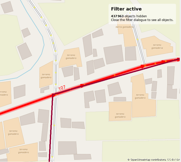
En maintenant la touche MAJ enfoncée et en cliquant sur d'autres voies, vous pouvez sélectionner plus d'une seule. Pour que certaines fonctions soient utiles, cela est nécessaire.
-
On clique sur Outils dans la barre supérieure:
-
Ensuite, nous avons les options suivantes en fonction de notre sélection:
-
Partager une ligne: Utilisé pour faire deux voies à partir d'une. Cela est utile lorsque vous ajoutez un itinéraire à OSM et qu'un chemin est plus long que l'itinéraire qui le suit. Habituellement, vous voulez vous séparer à la position où la ligne rouge foncé suit son propre chemin. (voir l'image ci-dessus). Voir aussi mon tutoriel dédié.
- Fusionner des chemins: Utilisé pour faire un chemin à partir de deux chemins. Le contraire de la fonction Partager une ligne. Pour que cette fonction soit efficace, vous devez sélectionner deux voies en maintenant la touche SHIFT enfoncée et en les sélectionnant.
- Non sélectionné:
- Sélectionné:

- Non sélectionné:
- Reserve direction: Used to reserve the direction of one or more ways. This just changes the technical direction how the data was entered (beginning to draw the way from left to right or backwards). Mappers use this tool just to make technical data more clean. This feature does not affect the interpretation of the data, it doesn't affect tags. You likely don't need it.
- Simplify way: Used to remove unncessary nodes from a way. Technically a bunch of nodes connected to each other in a specified order represent a way. This is another option to make OSM data more beautiful, it does not affect the tags from the way itself. Nodes on a way usually don't have tags (are empty).
- Align nodes in a circle: This function does what it says. This is another feature you rarely need.
- Align nodes in a line: Useful if you have a bunch of nodes like different points in a coordinate system in maths (e.g. data representation as a cloud.) in a specified treshold e.g. within range of 0.5cm and you want to create a line out of this node then this function is for you.
- Distribute Nodes: ToDo: find out what it does and create an easy to understand explanation.
- Orthogonalise Shape: ToDo: find out what it does and create an easy to understand explanation.
- Follow line: For this to be effective you need two selected ways. A way can share nodes with another line. This function continues drawing that line.
- Add node: A way is a representation of nodes connected to each other in a sorted linear order. This function adds a node to the selected way and prompts you for entering its coordinates.
- Move node: Select just one node for this function to be effective. It prompts you entering its new coordinates.
- Create circle: Similiar to function Align nodes in a circle but it works with just three nodes.
- Merge nodes: For this to be effective you need to just select nodes in order to merge them together: Merging their tags.
- Join node to way Arrange a selected node's and a selected way's marriage.
- Move node onto way: Moves and includes the selected node to the nearest way.
- Disconnect node from way: Arrange a selected node's and a selected way's seperation.
- UnGlue ways: Duplicate nodes shared by more than one way.
- Join overlapping areas: Join an area (closed way) which overlaps with another area into that area.
- Create multipolygon: Create a multiploygon out of the selection of ways and nodes. A multipolygon allows the exclusion of something inside of it and is useful in cases where something is in the area of a closed way but which has its own boundaries for making entering something more difficult.
- Update multipolygon: Similiar to the previous function but updates the area with the selected ways and nodes.